

Take a hike or a paddle with the Florida Trail Association
 The Walton area has two Florida Trail Groups, Choctawhatchee and Panhandle Chapters. Click the links below for upcoming events:
Click here for Choctawhatchee Chapter
Click here for Panhandle Chapter
____________________________________________________________
Trail Maps:
North Walton:
NokuseTrail
BayLoopTrail
South Walton:
TopsailHillStateParkTrail
PointWashingtonstateforest
GreenwayTrail
GraytonBeachTrails
____________________________________________________________
Hike or bike the Cassine trail in South Walton

Located within the Point Washington State Forest and part of its Eastern Lake Trail System, Cassine Gardens trail offers a pleasant, easy hike showcasing the diversity of Northwest Florida’s ecosystems.
The majority of this pleasant, less than one-mile hike consists of basin swamps/titi drains and wet flatwoods. Most colorful in spring and fall for the variety of wildflowers it hosts, you can enjoy this hike either by walking or biking. Midway through the hike at the turn around, the trail winds past the northwest portion of Eastern Lake. This resting spot offers a stellar view of one of the area’s rare coastal dune lakes. This location is also the connector to other legs of the trail system. Click here for entire Eastern Lake trail map
Trees and plants along the trail include Florida anise, southern magnolia, pond cypress, titi, red maple, pines, scrub oak, hickory, short-leaved rosemary, minty (wild) rosemary, fetterbush, saw palmetto, spiderwort, prickly pear cactus to name a few; along with a variety of ferns, mosses and lichen as well.
____________________________________________________________
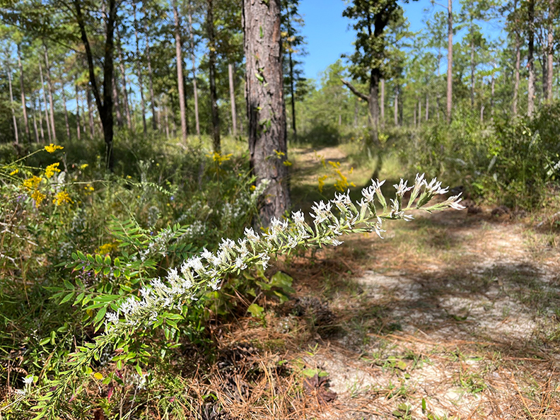
Creek side natural beauty awaits the explorer on the Florida Trail in Bruce
 The Nokuse Plantation portion the Florida Trail offers upland, wetland and freshwater natural habitats along the Lafayette Creek and Big Head Branch creek in Walton County. Whether you chose a short two-hour hike or an overnight backpacking journey, this trail offers a scenic experience that is sure to please.
This section of the Florida Scenic Trail stretches more than 19 miles from SR81 to U.S. Hwy. 331 in Freeport with three trailheads: SR81 between Bruce and Red Bay, J.W. Hollington Road in Freeport and U.S. Hwy 331 in Freeport.
If you chose a short, 2-3 hour hike, the SR81 trailhead near Seven Runs Creek, provides a shady, moderate hike along the Big Head Branch creek.
This undisturbed pristine area is adjacent to a planted pine forest along an easement provided by Nokuse Plantation. Nokuse Plantation is a privately owned preservation and restoration area connecting conservation lands of Eglin Reservation, Lafayette Wildlife Management Area and the Choctawhatchee Wildlife Management Area. Click to continue
____________________________________________________________
Fish, hike, paddle and enjoy birding on the coastal dune lakes of South Walton
 Recreational activities abound on these rare coastal dune lakes
Walton County Florida is well known for its beautiful beaches and great fishing. Less known to those that have never visited the area, are the unique and scenic coastal dune lakes that dot the coastline along the area’s beach dune systems.
Nestled along Scenic Highway 30A, Walton county’s coastal dune lakes are rare geological features that only occur in the Florida Panhandle, Madagascar, Australia, New Zealand and the northern Pacific coast of the United States.
Streams, groundwater seepage and rain are the sources that feed the coastal dune lakes. Storm surge creates intermittent connections to the Gulf of Mexico, called outfalls. This periodic connection empties lake water into the Gulf, and, depending on tides and weather, salt water and organisms from the Gulf flow back into the lakes. Click to continue
____________________________________________________________
Explore the Creek Trail in Santa Rosa Beach

Four miles of meandering trails a pleasant walk or bike ride
Many folks aren’t aware of a great little trail to explore in Santa Rosa Beach. Located around the busy South Walton Government Annex buildings, the Creek Trail offers four miles of hiking and biking enjoyment. Easily accessible, one can meander through the trails and enjoy the beauty of South Walton’s natural resources.
The Creek Trail totals approximately four miles of forest footpaths, multi-use paved trails, and bridges crossing over wetlands areas. A variety of trees such as sand pine, scrub oak, magnolia, titi, pond cypress and wax myrtle provide a shaded canopy throughout a portion of the trail system.
If you are looking for a short hike, bike ride or a great way to pass some time, head over to the Creek Trail. Click here to continue
____________________________________________________________
Hiking, biking, riding and birding trails in the Walton County area

Walton County, Florida offers a number of trails available to the hiker, biker, birder and horse rider. Maintained and managed by several different agencies and properties, including the state’s Florida Trail, Division of Forestry, and the County, there are a diverse number to choose from depending on a trekker’s interests.
Here is a comprised list of the larger trails available in the area. Some of the maps complementing the information below has been provided by the respective agencies, and Walton Outdoors shares these maps as general guidelines.
The map above is a general location indicator with corresponding numbers to the areas listed below.
Florida Trail
1. Florida Trail Nokuse Lafayette Creek
The eastern end is on State Road 81 just north of Bruce in Freeport just south of the Seven Runs Creek Recreation area. The eastern end spans westward to U.S. Hwy 331 were it joins for the Florida Eglin East Trail.

This is a new trail section opened in October 2008. It runs along the border of the Nokuse Plantation. Trail lovers hiking Nokuse Plantation trail segment see unique steephead habitats, gopher tortoise relocation and restoration of longleaf pine.
Completion of this section of hiking trail closes a significant gap in the 1,400-mile Florida National Scenic Trail that winds along a wilderness corridor the length of Florida. Hikers can explore natural Florida and learn about the area’s biodiversity along the trail.
Length: 15.9 miles (linear)
____________________________________________________________
Season brings colorful display to the Point Washington State Forest

Most any time of year, the Point Washington State Forest offers a diverse landscape for a hiker or biker to explore our area’s natural beauty. Most of the forest’s area consists of sandhill, basin swamps/titi drains, wet flatwoods, wet prairie and cypress swamps.
During the fall months, the array of wildflowers in bloom offer the explorer a colorful journey. Native flowers in bloom include wild buckweat (Eriogonum tomentosum), hairy jointweed (Polygonella basiramia), senna symeria (seymeria cassioides), goldenaster (Chrysopsis sabrella), goldenrod (Soldago tortifolia), figwort (Agalinis satacea) and blazing star (Litatris champanii) to name a few.

No overnight camping is currently permitted on the forest. There is camping available at both the Grayton Beach State Park and the Topsail Hill State Preserve State Park. These areas are located adjacent to the forest.
Hikers note: Point Washington State Forest is part of the Point Washington Wildlife Management Area. The Fish and Wildlife Conservation Commission regulates the hunting seasons in the forest. Visit MyFWC.com/hunting for information.
During hunting season be sure to wear bright colored clothing when hiking in the area.
For local information contact:
Division of Forestry
Point Washington State Forest
5865 East U.S. Hwy 98
Santa Rosa Beach, FL 32459
Telephone: 850/ 267-8325 or
Email Point Washington State Forest: vanderj@doacs.state.fl.us
For local information call (850) 682-6098 or http://choctaw.floridatrail.org

2. Florida Trail Eglin East Trail
The eastern end of this section is on US 331 just north of Freeport. The western end is at the SR 285 trailhead, 2.0 miles south of Interstate 10.
Length: 32.9 miles (linear)
Hiking is on an active military reservation. Of special interest is Eglin’s role as a weapons development and testing facility. The rumbles in the distance are rarely thunder.

Hikers on Eglin AFB are restricted to within 100 yards of the blazed FNST, side trails and designated campsites. Camping is authorized only at designated campsites and fires are restricted to fire rings in the campsites.
Eglin requires that all hikers age 16 or older, except thru-hikers (see below), to have in their possession a valid Eglin Recreation Permit. An annual (Oct 1 to Sept 30) recreation permit cost $10 and can be purchased at the Eglin Natural Resources Branch, 107 Hwy 85 North, Niceville FL, 32578. (850) 882-4164. Permits may be purchased through the mail with a check or money order and a copy of a photo ID.
While on the trail, all hikers must also complete and carry the tear-off Hiker Registration Cards that are available at each trailhead kiosk they pass (US 331, Alaqua). All hikers are also required to carry positive proof of identification. All overnight campers, except for FT thru-hikers (see below), must also purchase a $10 Camping Permit which covers groups up to 10 for 5 days.
As an aid to thru-hikers (backpackers starting and ending their hikes 30 miles beyond Eglin’s boundaries), Eglin does not require thru-hikers to obtain a Recreation or Camping Permit. In lieu of these permits, thru-hikers must have in their possession an official letter from FTA confirming their status as a thru-hiker and listing approximate dates of travel within Eglin. Thru-hikers are also required to complete a Hiker Registration Card at each trailhead kiosk and have the bottom part in their possession while on Eglin AFB.
Click here to continue
____________________________________________________________
Forest trail at southern side of Ponce de Leon Springs State Park
The 386-acre Ponce de Leon Springs State Park straddles Walton and Holmes counties. 154 undeveloped acres along the southern portion of the park off of J.D. Anderson Road offers a beautiful, easy hike. Prescribed burns have opened up the canopies in the forest restoring native pitcher plants, wiregrass, and fall wildflowers.
The park now offers four miles of trail opportunities in their previously undeveloped southern section of the park. In addition to the popular spring area, the park has converted their service roads. This portion of the park offers scenic views of upland, bottomland, and wetland areas. The trail is moderate terrain and suitable for hiking or biking.
Along the wetland areas, a variety of plants can be found such as pitcher plants, sundews, grass pink, and hatpins. On the upland portions, you may see rhododendron, red chokeberry, milkweed, hickory, huckleberry, blazing star, aster, oaks, pines, blueberry, and more. Gopher tortoise, turkey, fox, white-tailed deer, beaver, bobcat, otter, and a variety of native and migratory birds also inhabit the area. Historical elements such as turpentine remnants and an old railroad bridge can also be found.
Hours of Operation
8 a.m. to sunset
Driving Directions
Ponce de Leon Springs State Park Area is located one half mile south of U.S. 90 on C.R. 181A in Ponce de Leon, FL. ::MAP::
Park Fees
$4.00 per vehicle. Please use the honor box to pay fees. Correct change is required. Limit 8 people per vehicle.
$2.00 Pedestrians, bicyclists, extra passengers, passengers in vehicle with holder of Annual Individual Entrance Pass.
Ponce de Leon Springs State Park
2860 Ponce de Leon Springs Road (check in at main park for directions to the southern trail)
Ponce de Leon, Florida 32455
Phone: 850-836-4281
For more information, click here for the park’s website.
____________________________________________________________
Creek side natural beauty awaits the explorer on the Florida Trail in Bruce
 The Nokuse Plantation portion the Florida Trail offers upland, wetland and freshwater natural habitats along the Lafayette Creek and Big Head Branch creek in Walton County. Whether you chose a short two-hour hike or an overnight backpacking journey, this trail offers a scenic experience that is sure to please.
This section of the Florida Scenic Trail stretches more than 19 miles from SR81 to U.S. Hwy. 331 in Freeport with three trailheads: SR81 between Bruce and Red Bay, J.W. Hollington Road in Freeport and U.S. Hwy 331 in Freeport.
If you chose a short, 2-3 hour hike, the SR81 trailhead near Seven Runs Creek, provides a shady, moderate hike along the Big Head Branch creek.
This undisturbed pristine area is adjacent to a planted pine forest along an easement provided by Nokuse Plantation. Nokuse Plantation is a privately owned preservation and restoration area connecting conservation lands of Eglin Reservation, Lafayette Wildlife Management Area and the Choctawhatchee Wildlife Management Area. Click to continue
____________________________________________________________
Explore Lakewood Park: Florida highest point

At a whopping 345 ft. above sea level, there is no need for any mountain climbing gear to get to the top of Florida’s highest point. Lakewood Park in north Walton is the highest natural point in the State of Florida, and is also the lowest high point of any State in the U.S.
Located just east of Paxton, Lakewood Park is a small county park sporting picnic areas, a restroom and short hiking trails. The trails are an easy walk through a small hardwood forest of mostly even terrain. It offers three paths to choose from: .45 mile, .52 mile and .71 mile.
Known as Britton Hill to the locals, the namesake comes from a former lumber mill baron, William Henry Britton who developed the area in the early 1900s.
If you are exploring north Walton County, or headed to Florala, it is worth a stop.
Directions: Take U.S. Hwy 331 north. Turn east on Co. Hwy. 147E just south of Paxton. Turn left on N. Co. Hwy 285. The park is on the left. ::MAP::
____________________________________________________________
Florida Trail Eglin East Trail

The eastern end of this section is on US 331 just north of Freeport. The western end is at the SR 285 trailhead, 2.0 miles south of Interstate 10.
Length: 32.9 miles (linear)
Hiking is on an active military reservation. Of special interest is Eglin’s role as a weapons development and testing facility. The rumbles in the distance are rarely thunder.

Hikers on Eglin AFB are restricted to within 100 yards of the blazed FNST, side trails and designated campsites. Camping is authorized only at designated campsites and fires are restricted to fire rings in the campsites.
Eglin requires that all hikers age 16 or older, except thru-hikers (see below), to have in their possession a valid Eglin Recreation Permit. An annual (Oct 1 to Sept 30) recreation permit cost $10 and can be purchased at the Eglin Natural Resources Branch, 107 Hwy 85 North, Niceville FL, 32578. (850) 882-4164. Permits may be purchased through the mail with a check or money order and a copy of a photo ID.
While on the trail, all hikers must also complete and carry the tear-off Hiker Registration Cards that are available at each trailhead kiosk they pass (US 331, Alaqua). All hikers are also required to carry positive proof of identification. All overnight campers, except for FT thru-hikers (see below), must also purchase a $10 Camping Permit which covers groups up to 10 for 5 days.
As an aid to thru-hikers (backpackers starting and ending their hikes 30 miles beyond Eglin’s boundaries), Eglin does not require thru-hikers to obtain a Recreation or Camping Permit. In lieu of these permits, thru-hikers must have in their possession an official letter from FTA confirming their status as a thru-hiker and listing approximate dates of travel within Eglin. Thru-hikers are also required to complete a Hiker Registration Card at each trailhead kiosk and have the bottom part in their possession while on Eglin AFB.
A variety of nature trails await the explorer at Conservation Park in Panama City Beach

Looking for a great park to explore and hike a new trail? Then head over to the newly completed Conservation Park in Panama City Beach for a great little nature trek.
With more than 22 miles of trails, the newly completed Conservation Park in Panama City offers a variety of choices suited for both the bicyclist and hiker. There are several marked trails along with way finding kiosks to point the hiker in the right direction. More than a mile of boardwalks offer overlooks into the wetland areas with great views of pond cypress trees towering above. The park also boasts shaded picnic areas, an outdoor amphitheater, restrooms and ADA access.

Formerly a pine plantation, native habitat includes 800 acres of sand pine scrub and pine flat woods, with the remaining wetland areas boasting several large cypress domes.
The park project began more than 10 years ago as an alternative to routing treated wastewater into West Bay. The 3,000-acre parcel was purchased by Panama City Beach from St. Joe Company to create a dispersing basin.
More than 14 miles of new pipes disperse the water in four separate areas throughout the park. Outfall structures release the treated water at ground level in a natural setting. Click here to continue
____________________________________________________________